Part 2: Current Speed-Limit-Setting Law

Current Speed-Limit-Setting Law

In this part of the Toolkit, the various flexibilities related to speed limit setting in California are discussed in greater detail. Most, but not all, of these flexibilities relate to AB 43, AB 1938, or AB 1014. It is important to note that each method described below has some specific requirements or features that jurisdictions need to pay attention to for implementation; the requirements or features associated with each method are described accordingly using the following definitions:

E&TS needed for radar enforcement: If jurisdictions wish to enforce using radar, an E&TS must be conducted and updated regularly (see CVC § 627 and CVC § 40802).

Exempt from certain speed trap provisions: Most roadways in California require an E&TS to justify radar enforcement (see above). If no valid E&TS exists and enforcement is pursued, this is considered a “speed trap” (which is not legal in California). However, some roadway types do not require an E&TS for radar enforcement — these roadways are therefore exempt from this requirement of the speed trap provisions (see CVC § 40802).

No signage required: On local roads and in certain prima facie zones (i.e., business districts, railway grade crossings with an obstructed view, uncontrolled intersections with an obstructed view, and alleys), the prima facie speed limits apply even in the absence of actual speed limit signage.

Signage required: In other prima facie zones (i.e., business activity districts and school, senior, and playground zones), prima facie speed limits apply only when speed limit signage is present

Ordinance/resolution required: While some flexibilities in speed limit setting can simply be accomplished with no action from local government, many other flexibilities can only be undertaken after a local governing body (e.g. city council or county board of supervisors) has voted on and passed an ordinance or resolution to allow speed limit changes to take place on a specific corridor.

AB 43 changes: When proposals for speed limit changes are presented to elected officials, it is helpful to clarify in the rationale whether the requested flexibility is linked to AB 43. In any cases where the changes pertain to AB 43 (for locally-controlled roads), AB 1014 is also applicable (for state-controlled roads).

1. Prima Facie Speed Limit Setting Options for Common Context-Sensitive Zones

The California Vehicle Code (CVC) designates prima facie speed limits to govern vehicular speeds on roads that may not have speed limits. A prima facie speed limit is a default speed limit that applies under conditions when a posted speed limit is not determined based on an E&TS. Several types of prima facie speed limits and the areas they apply to respectively are described below, with notation when this zone has received updated treatment under AB 43 or AB 1014. Note that some prima facie zones require an E&TS for radar enforceability, and some do not.

1. 25 mph prima facie zones:  The following areas may have a prima facie speed limit of 25 mph (one zone can go as low as 20 mph).

A. Residence District

If the density of buildings fronting the street is higher than a certain threshold, a street may be classified as a residence district. The ratio is 13+ houses or structures on one side, or 16+ houses or structures on both sides for every 0.25 miles of roadway. Refer to CVC §22352(b) regarding prima facie zones for residence districts and to CVC § 515 for the specific definitions of residence districts.

(No signage required, E&TS needed for radar enforcement)

—> Leads to Local Road Definition under Speed Trap Provisions

Local roads are exempt from certain speed trap provisions and may be radar enforceable without an E&TS. Roads can be classified as “local” under the “California Road Systems Map” or if they meet certain conditions that most narrower two-lane residential roadways would meet. Refer to CVC § 40802 for the specific definitions of local roads for speed trap definitions.

(No signage required, Exempt from certain speed trap provisions)

B. Business District 

If more than half of the property fronting a road is being used for business, the road may be classified as a business district. The minimum distance is 300 ft if properties on only one side of the road are counted, and 600 ft if properties on both sides of the road are counted. Refer to CVC §22352(b) regarding prima facie zones for business districts and to CVC § 235 and CVC § 240 for the specific definitions of business districts.

(No signage required, E&TS needed for radar enforcement)

—> Leads to Local Road Definition under Speed Trap Provisions

Local roads are exempt from certain speed trap provisions and may be radar enforceable without an E&TS. Roads can be classified as “local” under the “California Road Systems Map” or if they meet other specific conditions. Refer to CVC § 40802 for the specific definitions of local roads for speed trap definitions.   

(No signage required , Exempt from certain speed trap provisions)

C. Business Activity District (20 mph, 25 mph)

Newly created under AB 43 (and applicable under AB 1014), business activity districts can be established in commercial areas such as downtowns and neighborhood business corridors if the land use and roadway meet certain conditions. Roads in business activity districts may have a prima facie speed limit of 20 or 25 mph. Proceed to Part 4 of this toolkit for more details. Refer to CVC § 22358.9 for the specific definitions of business activity districts.

(Signage required, Exempt from certain speed trap provisions, Ordinance/resolution required, AB 43 changes)

D. Senior Zone 

If the road passes a senior center or other facility primarily used by senior citizens, a Senior Zone may be established. This only pertains to locally-controlled roadways. Refer to CVC §22352(b) regarding prima facie descriptions of senior zones.

(Signage required, Exempt from certain speed trap provisions)

  1. Time-specific prima facie zones: These areas may have a prima facie speed limit of 25, 20, or 15 mph. Please refer to CVC §22352(b) & (d), § 22352.5, §22358.4 and §22357.1

A. School Zone 

A time-restricted school zone speed limit of 25 or 20 mph can be established within 500 feet of school grounds in any direction. Under AB 382, a 20 mph speed limit can be established on locally-controlled roads with proper signage and requires an ordinance or resolution until January 1, 2031, after which point, 20 mph becomes the default statewide prima facie limit in all posted school zones. Refer to CVC § 22352(b) & (d) and § 22352.5 for specific definitions and requirements.

(Signage required, Exempt from certain speed trap provisions, Ordinance/resolution required for 20 mph prior to 2031)

—> Leads to AB 321: 15 mph school zones

AB 321 (2008) and AB 382 (2025) combine to allow jurisdictions to establish time-restricted 15 mph school zones and extended 25 mph school zones from 500 ft to 1000 ft from school zones. The 15 mph school zone may only be established in residence districts on roads with two or fewer lanes and a posted speed limit of 30 mph or less. Proceed to Part 3 of this toolkit for more details. Refer to CVC §22358.4 for specific definitions and requirements.

(Signage required, Exempt from certain speed trap provisions, Ordinance/resolution required)

B. Children’s playground 

A time-restricted 25 mph prima facie speed limit may be established on locally-controlled roadways adjacent to any children's playground in a public park. Refer to CVC §22357.1

(Signage required, Exempt from certain speed trap provisions, Ordinance/resolution required)

3. 15 mph prima facie zones 

A prima facie speed limit of 15 mph applies to the following specific circumstances. Please refer to CVC §22352(a)

A. Railway grade crossing with obstructed view 

(No signage required, Exempt from certain speed trap provisions)

B. Uncontrolled intersection of public roads with obstructed view 

(No signage required, Exempt from certain speed trap provisions)

Image of a car at an intersection. The view of the driver is obstructed by bushes.

Source: Lehighvalleylive.com

C. Alley

Roads serving rear or side entrances with a width at or under 25 ft. Refer to CVC §22352(a) and CVC §110 for specific definitions and requirements.

(No signage required, Exempt from certain speed trap provisions)

Image of an alley with pedestrians walking by.

Source: Washingtonian.com

A summary of the type of zones and their respective prima facie speeds are provided in Table 1 below.

Table 1: Prima Facie Speed Limit by Locally-Controlled Road Context

Locally-controlled road contextPrima facie speed limitExceptions allowed?E&TS required for radar enforcement?
Residence District25 mphNoYes, unless a road is deemed a “local road"
Business District25 mphNoYes, unless a road is deemed a “local road"
Business Activity District20 mph or 25 mphNoNo
Senior Zone25 mphNoNo
School Zone25 mph (will become 20 mph on January 1, 2031 per AB 382)Yes (with proper signage, can be lowered to 20 mph by local ordinance/resolution; AB 321 allows for 15 mph speed limits under certain conditions)No
Children’s playground25 mphNoNo
Railway grade crossing with obstructed view15 mphNoNo
Uncontrolled intersection of public roads with obstructive view15 mphNoNo
Alley15 mphNoNo

2. Opportunities to Utilize Recent State Legislative Changes in Safe Speed Limit Setting (AB 43, AB 1938 & AB 1014)

Together, AB 43 (2021), AB 1938 (2022), and AB 1014 (2025) give jurisdictions the ability to consider lowering speed limits and include additional provisions affecting E&TS procedures and radar enforceability. A summary of the key changes that apply to speed limit setting are provided below, but see sections 4, 5, 6, 7, and 8 for more details

Each of these changes is applicable to both locally-controlled and state-controlled roads:

  1. Establishing a prima facie speed limit for a Business Activity District

  2. Designating road as a Safety Corridor (High Injury Network) to lower speed limit

  3. Designating road as a High Pedestrian and Bicycle Activity Area to lower speed limit

  4. Retaining current or restoring immediately prior speed limits if E&TS speed is higher than reasonable/safe and no general-purpose lanes were added

  5. Extending the E&TS validity period based on judgment of a registered engineer

  6. Rounding speed limit down to the nearest 5 mph instead of rounding up

  7. Declaring a 15 or 20 mph speed limit on a non-local road if justified by an E&TS

  8. Declaring a speed limit as low as 15 mph on a local road

All of the above require an E&TS except for numbers 1 and 8 (Business Activity District, and local roads). However, even in these cases, it is still recommended for the reviewing agency to include the affected roadways in their report to the court concerning speed limit changes and provide justification for the speed limit zone implementation.

3. 15 mph, 20 mph, and Extended 25 mph School Zones 

Together, AB 382 (2025) and AB 321 (2008) provide additional flexibility for prima facie speed limit setting in and just outside of school zones. A school zone is an area of any roadway within 500 feet of school grounds in any direction. Signs to indicate it is a school zone must be posted.

Beginning on January 1, 2031, the new prima facie speed limit in school zones will be 20 mph statewide. Prior to this date, jurisdictions may establish 20 mph prima facie speed limits in school zones through an ordinance/resolution. Refer to CVC §22352(b) & (d) and § 22352.5 for specific definitions and requirements. 

Local jurisdictions can establish 15 mph school zone speed limits on certain roadways within school zones and extended 25 mph school zone speed limits up to 1000 feet from the school zone. Refer to CVC § 22358.4 for specific definitions and requirements.

  • 20 mph school zone prima facie speed limits can be established by local ordinance or resolution prior to January 1, 2031, but will become the default prima facie speed limit thereafter.

(Signage required, Exempt from certain speed trap provisions, Ordinance/resolution required)

  • 15 mph school zone prima facie speed limits can be established if all of the following requirements are met:

    • On any roadway within 500 feet of school grounds, provided signs are posted to indicate it is a school zone. 

    • In a residence district (refer to CVC § 240).

    • On a road with two or fewer travel lanes. 

    • On a road with a maximum posted speed limit of 30 mph before and after the school zone. Note: it may be possible to reduce surrounding 35 mph zones to 30 mph using other criteria to allow for this option.

(Signage required, Exempt from certain speed trap provisions, Ordinance/resolution required)

  • Extended 25 mph school zone prima facie speed limits can be established 500 ft to 1000 ft from a school zone:

(Signage required, Exempt from certain speed trap provisions, Ordinance/resolution required)

As an example, using AB 321 (2008), the City of Sacramento implemented 15 mph school zone speed limits and/or 25 mph extended school zone speed limits across 225 road segments near 115 schools.

4. Business Activity Districts (AB 43 and AB 1014 change)

Newly created under AB 43 and expanded under AB 1014, business activity districts can be established in commercial areas such as downtowns and neighborhood business corridors if the land use and roadway meet certain conditions. Roads in business activity districts may have a prima facie speed limit of 20 or 25 mph without the need for an E&TS. Refer to CVC § 22358.9 for the specific definitions of business activity districts.

Example of Business Activity District with High Pedestrian and Bike Activity

Image of people talking and standing around a bike rack.

Source: Adventure Cycling Association 

To qualify as a business activity district, the following criteria should be used to assess a corridor:

a. All of the following must be true: Located in commercial areas such as downtowns or neighborhood business corridors AND on a road with four or fewer travel lanes. 

b. AND 1 of the following must be true: 

i. A maximum posted speed limit of 30 mph before and after a proposed 25 mph business activity district.  Note: it may be possible to reduce surrounding 35 mph zones to 30 mph using other criteria to allow for this option. 

ii. A maximum posted speed limit of 25 mph before and after a proposed 20 mph business activity district. Note: it may be possible to reduce surrounding 30 mph zones to 25 mph using other criteria to allow for this option.

c. AND contains at least 3 out of 4 of the following:

i. At least half of the contiguous properties are for retail or dining commercial uses. 

ii. On-street parking. 

iii. Signals or stop signs are located at intervals of no more than 600 feet.

iv. Marked crosswalks that are not controlled by a traffic control device.

(Signage required, Exempt from certain speed trap provisions, Ordinance/resolution required, AB 43 changes)

Example of a Business District with Many Shops and High Pedestrian Activity
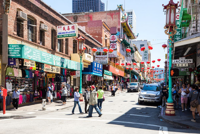
Image of pedestrians crossing the street in San Francisco’s Chinatown.

Source: Curbed San Francisco

Business activity districts with 20 mph or 25 mph speed limits cannot be established on roads that have leveraged any of the other AB 43 or AB 1014 changes (see sections 5, 6, 7 below): further reducing the speed limit by 5 mph using the designations of “safety corridor” or “high concentrations of bicyclists or pedestrians” or when retaining the existing or restoring the immediately prior speed limit. Therefore, jurisdictions can consider implementing 20 mph or 25 mph business activity district speed limits prior to implementing other elements of AB 43 or AB 1014 changes. 

The City of San José has implemented 20 mph business activity district speed limits on 6 corridors both in downtown and other commercial areas (City of San José 2022).

Example of a Business Activity District with Many Retail Uses
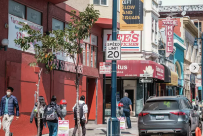
 Image of a retail district with pedestrian traffic and a 20 mph speed limit sign.

Source: San Francisco Chronicle

5. Land or Facility that Generates High Concentrations of Bicyclists or Pedestrians (new changes under AB 43 and AB 1014)

“Land or facility that generates high concentrations of bicyclists and pedestrians” (also known as high concentration of bike and ped) is one of two options under AB 43 and AB 1014 to consider reducing the speed limit by 5 mph in the E&TS process (see CVC § 22358.7(a)(2))). The other option is a Safety Corridor (see #6 below). If the 5 mph reduction is taken for a Safety Corridor, then the 5 mph for high concentration of bike and ped cannot be applied. Areas with high concentration of bike and ped may be places such as parks, transit hubs, or outdoor recreational centers that attract a considerable number of pedestrian and bicycle trips (NACTO, 2020). They may also simply be areas with designations for bicyclists or pedestrians, such as roadways with marked bike lanes or streets with sidewalks.

Roadways with high concentration of bike and ped can be defined in two ways. 

One of the following: 

  • Falling within 1320 ft of any generators listed in the CA MUTCD 2026 Table 2B-105(CA) (see below)

  • Within 1320 ft of a top 20% hotspot for pedestrian and/or bicyclist fatalities or serious injuries 

Table lists nineteen generators of high concentrations of bicyclists or pedestrians, as outlined in the CA MUTCD. For more information, please see the following summary.

Requirements to determine Land or Facility that Generates High Concentrations of Bicyclists or Pedestrians (Table 2B-105(CA))

Generators related to Land Use: 

  • Employment centers 

  • Presence of retail 

  • Parks, multi-use trails, and recreational destinations 

  • Schools/universities

  • Senior Centers 

  • Cultural areas, entertainment space areas, or areas of community significance

  • Religious facilities 

  • Health/medical facilities

Generators related to Transit Factors:

  • Transit stops 

  • Transit Oriented Developments/Transit Priority Areas

Generators related to Presence of Pedestrian/Bicyclist Infrastructure:

  • Sidewalk presence 

  • Crosswalk presence 

  • Bikeway presence 

  • Nearby signalized intersections on four-way intersections 

  • Presence of micromobility devices such as bicycles or scooters

Generators related to Demographic Factors:

  • Presence of vulnerable groups including children, seniors, persons with disabilities, users of personal assistive mobility devices, and the unhoused

  • MPO/RTPA or locally defined disadvantaged community status 

  • Presence of students (all levels)

Generators related to Local Data:

  • Need identified in a safety analysis, such as a road safety audit or formalized planning document such as a local road safety plan

Source: Adapted from California Manual on Uniform Traffic Control Devices (CA MUTCD) (California Department of Transportation, 2026)

Falling within 1320 ft of any generators listed in CA MUTCD Table 2B-105(CA)

Infographic detailing a generator and a sidewalk. At least one generator for every 1320 ft / 0.25 mi.

At least one generator for every 1320 ft / 0.25 mi

Infographic detailing a generator and a sidewalk with a bus stop. At least one generator for every 1320 ft / 0.25 mi.

Road segment within the top 20% of pedestrian and/or bicyclist fatalities or serious injuries

Infographic detailing a sidewalk with pedestrians and bicyclists. At least one generator for every 1320 ft / 0.25 mi.

(Exempt from certain speed trap provisions, Ordinance/resolution required, AB 43 changes) 

Practical Considerations

The list of generators is comprehensive and presents an opportunity for jurisdictions to flexibly apply the 5 mph further reduction. Any generator in CA MUTCD Table 2B-105(CA) can qualify a street as a “roadway with high concentration of bike and ped." Notably, generators such as sidewalk presence and crosswalk presence are very common, especially in urban areas.

6. Safety Corridor (new changes under AB 43 and AB 1014) 

A Safety Corridor is defined as a roadway segment within an overall roadway network (no more than one-fifth of the total network) where the highest number of serious injury and fatality crashes occur (see CVC § 22358.7(a)(1)). Safety Corridor designation is the second of two options under AB 43 and AB 1014 to reduce the speed limit by 5 mph in the E&TS process (the other being high concentration of bike and ped (see #5 above). If the 5 mph reduction is taken for high concentration of bike and ped, then the 5 mph for a Safety Corridor cannot be applied.

Safety Corridor and High Injury Network 

Safety Corridors are defined by the CA MUTCD as “a roadway segment within an overall roadway network where the highest number of serious injury and fatality crashes occur” (Caltrans, 2026). Often jurisdictions determine which corridor-level segments qualify as a Safety Corridor through a High Injury Network (HIN) analysis that satisfies the required specifications under the CA MUTCD. The Recommendations for California Statewide Guidance on High Injury Networks document summarizes the methodology for developing a HIN and points to numerous California case studies (“Recommendations for California Statewide Guidance on High Injury Networks,” 2021). The guidance document delineates the standards of eight core components for a HIN and provides a checklist of HIN development for local jurisdictions. In defining Safety Corridors, the CA MUTCD also allows local agencies to use proactive measures that predict crash risk, such as speeding data, conflict or near-miss data, or roadway characteristics, as a supplement to crash data from prior years. 

The HIN should represent a defined prioritized subset of the overall transportation network. Specifically for Safety Corridor designation, the HIN should be consistent with all the following requirements (refer to the CA MUTCD, including Table 2B-104(CA)) for the complete list of requirements for Safety Corridor designation):

  • Based on fatal and serious injury crashes

  • Uses three to five years of the most recent crash data 

  • Safety Corridor designation cannot exceed 20% of the jurisdiction’s roadways

  • Identify specific locations with high crash occurrences

  • Identify corridor-level segments with a pattern of crash reoccurrence 

  • Be able to be stratified by mode

  • Uses at least one required crash weighting factor listed in Table 2B-104(CA) (see below) to prioritize locations

Table lists the factors required to designate a roadway corridor as a safety corridor, as outlined by the CA MUTCD. For more information, please review the following summary.

Safety Corridor Definition Requirements (Table 2B-104(CA)):

Crash Weighting Factors to Develop One Serious/Fatal Injury Safety Corridor: 

  • Crash severity: Fatal Crashes, Serious Injury Crashes 

  • Mode: Pedestrian-bicycle related crashes, vehicle/other 

  • Disadvantaged Community Status: MPO/RTPA or locally defined disadvantaged community status based on most current version of CalEnviroScreen

  • Vulnerable Populations: Seniors (age 65 and older) and Youth (under age 15) based on the American Community Survey 

  • School proximity (within 0.25 miles) based on the California School Campus Database

  • Systemic or Predicted Crashes

Crash Density

  • Each roadway segment block may be converted into ~0.25-mile overlapping or contiguous "corridor" segments to create a consistent unit of measurement and assess the concentration of linear patterns of crashes within a defined distance. The highest scoring (i.e. most fatal and serious injury crashes per mile) "corridor" segments within a street needs to be identified and an appropriate threshold set to determine safety corridor eligibility.

Maintenance

  • The jurisdiction may establish a review and re-evaluation frequency for Safety Corridors. However, such frequency need not exceed seven years.

Source: Adapted from CA MUTCD 2026 Table 2B-104(CA): Safety Corridor Factors (Caltrans, 2026)

(Exempt from certain speed trap provisions, Ordinance/resolution required, AB 43 changes) 

Practical Considerations 

Safety Corridors connect HINs with Speed Limit Setting. Jurisdictions that have developed HINs may need to determine their conformance with Safety Corridor requirements as defined in the CA MUTCD prior to utilizing speed limit setting flexibility based on the Safety Corridor designation. 

For jurisdictions that have not developed HINs, the requirements for Safety Corridor designation and best practices can serve as guidance for their HIN development efforts (“Recommendations for California Statewide Guidance on High Injury Networks,” 2021). Safety Corridor designation might also be informed by analysis completed for a Local Road Safety Plan (LRSP) or Systemic Safety Analysis Report Program (SSARP). If none of these analyses (HIN, LRSP, SSARP) have been completed, jurisdictions can likely use crash data to designate a single corridor as a Safety Corridor, but this would require an objective analysis showing that the corridor’s safety issue is elevated when compared with the rest of the community or statewide averages. See the section on Collecting Supporting Materials to Enact Reduced Speed Zonesfor more information on data sources for this type of analysis.

Minimum core component standards for developing a High Injury Network

ComponentComponent Standard
YEARS OF DATAAn HIN should depend on between three and five years of collision data from a reliable source of data (up to 10 years may be appropriate, depending on the jurisdiction). Collision data may be derived from SWITRS, TIMS, or a jurisdiction's established database.
SHARE OF ROADWAY NETWORKAn HIN should represent a subset of an overall roadway network — typically between 5 percent and 20 percent. Jurisdictions should aim to identify a share less than 50 percent of the total roadway network as the HIN, to support a focused approach for future investments.
LEVEL OF ANALYSISAn HIN should be focused on corridors that are continuous and have comparable crash patterns or densities — considerations for corridor length can include land use, speed, and intersection spacing.
COLLISION DENSITYAn HIN should have a development threshold that captures a significant number of total KSI collisions — typically more than 40 percent.
ROADWAY FACILITY TYPESAn HIN should consider roadway facilities particularly ones for which they have the authority to establish speeds or conduct enforcement.
EQUITYAn HIN should take into account equity. For example, a jurisdiction could document how much of the proposed HIN falls into communities of concern or disadvantaged communities, or through more heavily weighting collisions occurring in these areas.
CONSIDERATION OF MODES (e.g., driver, bicyclist, pedestrian, etc.)An HIN should consider all modes of serious and fatal collisions, including bicyclists and pedestrians.
MAINTENANCEAn HIN should be re-evaluated when speed limits are surveyed/modified, land use characteristics change, data changes or other relevant changes occur.

Source: Adapted from Recommendations for California Statewide Guidance High Injury Networks (“Recommendations for California Statewide Guidance on High Injury Networks,” 2021)